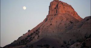
Ilam terrains are made from parallel folds in northwest and southeast. This sediment remains from first to the fourth period of Geology but they mostly belong to the second and third period. These mountains are so widespread that no plain has been shaped between them.
According to the province terrains, north and northeast of the province consist of high mountains and its west and southwest consist of low districts with a slope toward the west. Grand plains of Mehran District and Abbas plain are located in this district. The height of these plains is lower than 300 meters. The terrains which are near this district makes the height difference between these two sides 3000 meters. According to this natural feature, Nomad lifestyle shaped in this district.
Generally, north and northeast of Ilam are mountainous but southwest and west are low. The most important heights of the province are Kabir Kuh and Dinar Kuh.
Ilam is considered a tropical district of the country. But the mountains caused temperature differences and more rainfall in the north, south and west parts. These districts are cold and have long winters, their minimum temperature is 15 below zero and the level of rainfall is more than 500 millimeter each year.
West and southwest plain districts of the province are tropical. Their maximum temperature is near 200 millimeters each year.
The middle districts have mild weather. Its temperature reaches 5 below zero in winter and its maximum temperature in southern parts and Darreh Shahr is more than 40 Celsius in summer. According to synoptic station researches in 1375 SH, Ilam maximum temperature was 38 Celsius in August and its minimum was four Celsius below zero in February. The annual level of rainfall was 4/578 millimeters, maximum relative humidity was 64 percent and minimum relative humidity was 24 percent. 27 days of winter were icy in this year.
In Dehloran County, the maximum temperature was 49/6 Celsius in July and its minimum was two Celsius below zero in February, the annual level of rainfall was 3/340 millimeters, maximum relative humidity was 56 percent and minimum relative humidity was 32 percent. 3 days of winter were icy in this year.
Annual rainfall and being the groundwater drainage of Zagros Mount are the reasons which have caused so many rivers shaped in this district. So many dams and canals had been built there. Ilam underground water has not a good Topography feature but its duct and underground water are used.
- Please feel free to call us on 00989020038045 (Phone, Whatsapp, Telegram) or contact by info@mustseeiran.com, if you require any further information.
Follow us on Instagram @mustseeiran.com_insta