Geography Situation and County Subdivision of Ilam

Ilam area is about 19086 square kilometers, which is 4/1 percent of the entire country area. This province is located in west hills of Zagros Mounts between 31 degrees and 15-minute northern latitude of Equator and 45 degrees and 24 minutes to 48 degrees and 10-minute eastern latitude of Prime meridian in the western part of the country. Ilam is connected to Khuzestan from the south, Lorestan from east and Kermanshah from the north. It has 425-kilometers common border.
According to the last country subdivision in 1375, Ilam consists of seven Counties, seventeen villages, fifteen cities, thirty-six rural districts, and 753 villages.
Ilam counties are Abdanan, Ilam, Ivan, Darreh Shahr, Dehloran, Shirvan and Chardavol, and Mehran. The capital of the province is Ilam which named Arus Zagros (Zagros Bride) because of its beauty and eye-catching nature.

  • Please feel free to call us on 00989020038045 (Phone, Whatsapp, Telegram) or contact by info@mustseeiran.com, if you require any further information.
    Follow us on Instagram @mustseeiran.com_insta

Natural geography and climate of Ilam

Natural geography and climate of Ilam

Ilam terrains are made from parallel folds in northwest and southeast. This sediment remains from first to the fourth period of Geology but they mostly belong to the second and third period. These mountains are so widespread that no plain has been shaped between them.
According to the province terrains, north and northeast of the province consist of high mountains and its west and southwest consist of low districts with a slope toward the west. Grand plains of Mehran District and Abbas plain are located in this district. The height of these plains is lower than 300 meters. The terrains which are near this district makes the height difference between these two sides 3000 meters. According to this natural feature, Nomad lifestyle shaped in this district.
Generally, north and northeast of Ilam are mountainous but southwest and west are low. The most important heights of the province are Kabir Kuh and Dinar Kuh.
Ilam is considered a tropical district of the country. But the mountains caused temperature differences and more rainfall in the north, south and west parts. These districts are cold and have long winters, their minimum temperature is 15 below zero and the level of rainfall is more than 500 millimeter each year.
West and southwest plain districts of the province are tropical. Their maximum temperature is near 200 millimeters each year.
The middle districts have mild weather. Its temperature reaches 5 below zero in winter and its maximum temperature in southern parts and Darreh Shahr is more than 40 Celsius in summer. According to synoptic station researches in 1375 SH, Ilam maximum temperature was 38 Celsius in August and its minimum was four Celsius below zero in February. The annual level of rainfall was 4/578 millimeters, maximum relative humidity was 64 percent and minimum relative humidity was 24 percent. 27 days of winter were icy in this year.
In Dehloran County, the maximum temperature was 49/6 Celsius in July and its minimum was two Celsius below zero in February, the annual level of rainfall was 3/340 millimeters, maximum relative humidity was 56 percent and minimum relative humidity was 32 percent. 3 days of winter were icy in this year.
Annual rainfall and being the groundwater drainage of Zagros Mount are the reasons which have caused so many rivers shaped in this district. So many dams and canals had been built there. Ilam underground water has not a good Topography feature but its duct and underground water are used.

  • Please feel free to call us on 00989020038045 (Phone, Whatsapp, Telegram) or contact by info@mustseeiran.com, if you require any further information.
    Follow us on Instagram @mustseeiran.com_insta

Ilam Historical Geography

The province which named Ilam now was part of historical Ilam. This province was made 300 years BC and exist till 640 years BC. The province had been destroyed completely by Aahur Bani Pal Command. Some of its cities were; Shush (capital), Madakto (summertime capital), Ahavz, Khaydalu, Masabatic, and Kabyaneh.
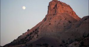
In Babeli inscriptions, Ilam was called Alamato or Alam and means Mountains or sunrise country. After Ilam fall, it has been divided into two parts; Persian Government in East part and Medes in the west part. Achaemenid army should pay to highlanders to pass Zagros Road.
According to historians in Seleucid Empire Zagros People fight with foreigners. The historical monuments of the Sasanid Empire in Ilam and Lorestan indicates this district was so important once. Here are some of its cities; Masbandan, Mehrekan Kadak, Dar Shahr, Seymareh, Arikhun, and Shiravan. The exact place of some of these cities is not determined yet.
In the last Sasanid Empire, Firuzan Dynasty governs the province and Khuzestan. Its last commander was sent to Darolkhelafeh after being beaten in Jola war. After Iran conquest by Arabs, it was estimated that this district was part of Kufeh and some of its cities are Masbandan, Mehregan, Seymareh, and Marab.
Late in 4th centuries AH till early 6th Centuries, Hassanudieh Kord govern Lorestan and Ilam.
From 570 to 1006 AH, Atabakan Lor governs Lorestan and Poshtkuh. The last commander, Shahurdikhan, was killed by Safavid Shah Abbas and Hossein Khan Silvarzi, give the position of the lorestan commander to ancestors of Valian Abuqedareh. The dynasty moves their government to Poshtkuh (nowadays Ilam) and Qolamreza Khan Abuqedare commander after 1299 rebellion refuged to Iraq.
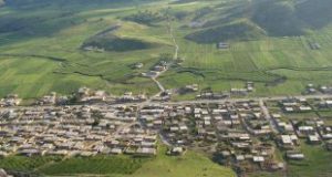
From 1309 SH, according to county subdivision, Ilam considered as the fifth province, Kermanshah. Then due to its political position become general governor and now is one of the important cities of the province.

  • Please feel free to call us on 00989020038045 (Phone, Whatsapp, Telegram) or contact by info@mustseeiran.com, if you require any further information.
    Follow us on Instagram @mustseeiran.com_insta

Dehloran County

Dehloran County

This city is located in south and southwest of Dinarkuh Hill and was known as Dehloran from ancient time.
The ancient and old things have been found there indicate that the antiquity of this district relates to prehistory especially the Sasanian Empire. Remains of historical cities and hills indicate the county old history.
Dehloran geographical position makes it an important city. Its position also causes lots of damage through history. Its importance is kept through further eras. The city destroyed a lot through the Iran Iraq War. The city was renovated after the war and was considered as an important tourist city.
Besides its tourist attraction has grand petroleum resources and agricultural fields which doubled its economic and geographical importance.

  • Please feel free to call us on 00989020038045 (Phone, Whatsapp, Telegram) or contact by info@mustseeiran.com, if you require any further information.
    Follow us on Instagram @mustseeiran.com_insta

Ivan County

Ivan County

Ivan County is a new county in Ilam Province. It has a good situation for agriculture and animal husbandry. This county is located between Ilam to Islam Abad and Gilan Qarb. The nature of the county is so eye-catching and its monuments are evidence of its oldness and civilization. The people of the county are from Kalhar Tribe and talk in Kalhari Language.

  • Please feel free to call us on 00989020038045 (Phone, Whatsapp, Telegram) or contact by info@mustseeiran.com, if you require any further information.
    Follow us on Instagram @mustseeiran.com_insta

Ab Aseman Abad River of Ilam

Ab Aseman Abad River of Ilam

This river originated from springs near Aseman Abad Village, 35 kilometers far from northwest of Ilam and runs from Qelajeh and Kateh Pifak Mount to southeast. After passing, Aseman Abad Villages enters Piran Mount and joins Chenarch River in Kabud Village and shape Chardavol River. The river length is 50 kilometer and source height is 1400 meters. This river is so awesome and beautiful.

  • Please feel free to call us on 00989020038045 (Phone, Whatsapp, Telegram) or contact by info@mustseeiran.com, if you require any further information.
    Follow us on Instagram @mustseeiran.com_insta

Talkhab River of Ilam

This river originated from Allahkhoda and Talvar Mounts of Boli Zangivan Sarchamlu and Kani Deldel which is 45 kilometers far from northeast of Ilam.after passing Chaman Boli, 61 kilometers far from west of Ilam exit Iran and enters Iraq. The river length is 43 kilometer and its source height is 1280 meter.

  • Please feel free to call us on 00989020038045 (Phone, Whatsapp, Telegram) or contact by info@mustseeiran.com, if you require any further information.
    Follow us on Instagram @mustseeiran.com_insta

Ab Darreh Jeke River of Dehloran

This river originated from Kabir Kuh southern Mounts which is located 3 kilometers far from west of Imamzadeh Shah Ahmad and 65 kilometers far from northeast of Dehloran. After passing west valley of the mount, 65 kilometers far from east of Dehloran joins Karkheh River. This river is 25 kilometers long and 1200 meter high.

  • Please feel free to call us on 00989020038045 (Phone, Whatsapp, Telegram) or contact by info@mustseeiran.com, if you require any further information.
    Follow us on Instagram @mustseeiran.com_insta

Chamava waterfall of Ilam


Chamava waterfall of Ilam

It is located 18 km far from Ilam-Salehabad and between Chamo and Marbareh. This spring originated from Ilam Mount and pour in Gedarkhosh River.

  • Please feel free to call us on 00989020038045 (Phone, Whatsapp, Telegram) or contact by info@mustseeiran.com, if you require any further information.
    Follow us on Instagram @mustseeiran.com_insta