Natural geography and climate of Ilam

Natural geography and climate of Ilam

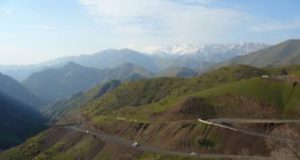
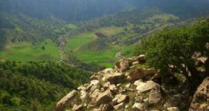
Ilam terrains are made from parallel folds in northwest and southeast. This sediment remains from first to the fourth period of Geology but they mostly belong to the second and third period. These mountains are so widespread that no plain has been shaped between them.
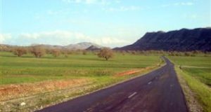
According to the province terrains, north and northeast of the province consist of high mountains and its west and southwest consist of low districts with a slope toward the west. Grand plains of Mehran District and Abbas plain are located in this district. The height of these plains is lower than 300 meters. The terrains which are near this district makes the height difference between these two sides 3000 meters. According to this natural feature, Nomad lifestyle shaped in this district.
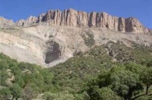
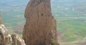
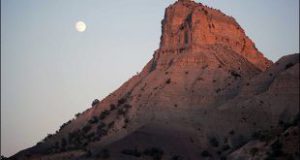
Generally, north and northeast of Ilam are mountainous but southwest and west are low. The most important heights of the province are Kabir Kuh and Dinar Kuh.
Ilam is considered a tropical district of the country. But the mountains caused temperature differences and more rainfall in the north, south and west parts. These districts are cold and have long winters, their minimum temperature is 15 below zero and the level of rainfall is more than 500 millimeter each year.
West and southwest plain districts of the province are tropical. Their maximum temperature is near 200 millimeters each year.
The middle districts have mild weather. Its temperature reaches 5 below zero in winter and its maximum temperature in southern parts and Darreh Shahr is more than 40 Celsius in summer. According to synoptic station researches in 1375 SH, Ilam maximum temperature was 38 Celsius in August and its minimum was four Celsius below zero in February. The annual level of rainfall was 4/578 millimeters, maximum relative humidity was 64 percent and minimum relative humidity was 24 percent. 27 days of winter were icy in this year.
In Dehloran County, the maximum temperature was 49/6 Celsius in July and its minimum was two Celsius below zero in February, the annual level of rainfall was 3/340 millimeters, maximum relative humidity was 56 percent and minimum relative humidity was 32 percent. 3 days of winter were icy in this year.
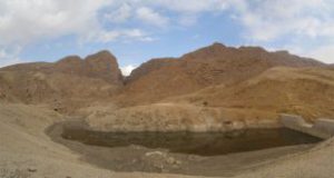
Annual rainfall and being the groundwater drainage of Zagros Mount are the reasons which have caused so many rivers shaped in this district. So many dams and canals had been built there. Ilam underground water has not a good Topography feature but its duct and underground water are used.

  • Please feel free to call us on 00989020038045 (Phone, Whatsapp, Telegram) or contact by info@mustseeiran.com, if you require any further information.
    Follow us on Instagram @mustseeiran.com_insta

Dehloran County

Dehloran County

This city is located in south and southwest of Dinarkuh Hill and was known as Dehloran from ancient time.
The ancient and old things have been found there indicate that the antiquity of this district relates to prehistory especially the Sasanian Empire. Remains of historical cities and hills indicate the county old history.
Dehloran geographical position makes it an important city. Its position also causes lots of damage through history. Its importance is kept through further eras. The city destroyed a lot through the Iran Iraq War. The city was renovated after the war and was considered as an important tourist city.
Besides its tourist attraction has grand petroleum resources and agricultural fields which doubled its economic and geographical importance.

  • Please feel free to call us on 00989020038045 (Phone, Whatsapp, Telegram) or contact by info@mustseeiran.com, if you require any further information.
    Follow us on Instagram @mustseeiran.com_insta

Manasht Mount of Ilam


Manasht Mount of Ilam

Manasht Mount is located 6 km far from northeast of Ilam. It is 2629 meter high. This mount originated from Murt and Esazangan River. It connects to Bankul Mount from its northwestern part, to Gaveh Mount from its southwestern part, and its western part is covered by Oak Jungles.

  • Please feel free to call us on 00989020038045 (Phone, Whatsapp, Telegram) or contact by info@mustseeiran.com, if you require any further information.
    Follow us on Instagram @mustseeiran.com_insta

Some of Ilam Mounts

Some of Ilam Mounts

Allah Khoda, Bayeh, Talvar, Jamalgir, Chapaq, Bababkhan, Chakbureh, Sefid, Som Khar, Katepifak, Malad Shah, Genu, and… Mounts in Ilam.
Bonhar, Darvand, Ravandi, Sargach, Sargach Kuh, Marzu, Haft Kalk, and… Mounts arelocated in Darreh Shahr County.
Barikab, Barak Kuy, Bete Ansh, Poshte Golab, Tapeh Ali Kasht, Khargahi, Dalpari, Tanila, Kalavandy, Kalviz, Kulunarmeh, Gutbeamaleh, and… Mounts are located in Dehloran County.
Balvand, Balijan, Choqal, Zardkuh, Siahkuh, Zaluab, Chencher, Sorkh, Sekurand, Siah Ardalan, Yek shabah, and …are located in Mehran.

  • Please feel free to call us on 00989020038045 (Phone, Whatsapp, Telegram) or contact by info@mustseeiran.com, if you require any further information.
    Follow us on Instagram @mustseeiran.com_insta

Telesm Ivan Cave of Ilam

This cave is located in the east of Sarab Village, Darij Mounts and at the top of Manasht Mount.
This cave was identified by mountaineering club of Ilam and Ministry of Culture and Islamic Guidance in 1369 SH.
Due to its special situation and the dead body of animals, it is a suitable place for predators. There are also some bats in this cave.
Here are some of the cave features;
The cave is 300 meters long, and only 100 meters of the area is open. The ceiling has stalactite raises. There is a three-way direction and one of its corridors is 20 meters deep and the other is much narrower 10 meters further. Then the way would become hard to pass and after that, the cave extended to 200 meters depth circularly.
From 260 meter length further, the way would become narrower. This part of the cave has collapsed but its depth continues to the end of the cave (which is 300 meters long). The cave stones are made from lime and rocky and some part of the floor is dusty.

  • Please feel free to call us on 00989020038045 (Phone, Whatsapp, Telegram) or contact by info@mustseeiran.com, if you require any further information.

Follow us on Instagram @mustseeiran.com_insta

Ivan Enfejari Cave of Ilam

This cave is located in the north of Kalejo Village of Ivan County, in the west of Bankul Mount. The cave entrance is circular, 1/5 meter deep and hard to pass. People should crawl to enter.
After entering you will reach a big gallery an then the cave divided into two parts. One of them is like a hallway, five meters high, ten meters wide, 40 meters deep and covered by Limestone, stalactite. Then there would be a deep slope which its depth is not estimated yet.
Limestone layers of the ceiling affected cave stones because of the cave temperature and cause them to fall from the ceiling and its name derived from this circumstance (Enfejari= exploding). It is estimated that water sources are in the deepest part of the cave.

  • Please feel free to call us on 00989020038045 (Phone, Whatsapp, Telegram) or contact by info@mustseeiran.com, if you require any further information.
    Follow us on Instagram @mustseeiran.com_insta

Tajrian Promenade of Ilam

Tajrian Promenade of Ilam

This promenade is located 20 km far from Ilam, in Chovar-Mort va Boli Road. It has lots of springs. It is near Behesht Strait and it is actually visited from winter to spring according to its weather.

  • Please feel free to call us on 00989020038045 (Phone, Whatsapp, Telegram) or contact by info@mustseeiran.com, if you require any further information.
    Follow us on Instagram @mustseeiran.com_insta

Kalam Bedareh Promenade of Ilam Province

Kalam Bedareh Promenade of Ilam Province

This promenade is located 70 km far from Ilam in Dareh Kalam (between Ilam –Badreh). The gardens, different kinds of vegetable, a river which originated from Kabirkuh make this place such a wonderful place in the Province.
The whole year is suitable for visiting such a great place especially summertime. Visitors are mostly the people who lived near the Province.

  • Please feel free to call us on 00989020038045 (Phone, Whatsapp, Telegram) or contact by info@mustseeiran.com, if you require any further information.
    Follow us on Instagram @mustseeiran.com_insta

Promenades of Ilam

Forest promenade like Male Panjav, Haji Bakhtiar and Abza, Manjal, Tang Arqavan around Ilam.
Forest promenade is near Mehram dome, and Kanjan Cham River is located 6 km far from Slehabad of Mehran County.
Beautiful nature of Tang Qir in Chardavol.
Plains and pasture’s view of Shirvan and Chardavol.
Nature of Sohrab Promenade in Abdanan.
Natural views of Kabirkuh and Seymareh River in Darreh Shahr County.
Natural views of Anaran Mounts in Abdanan County.

  • Please feel free to call us on 00989020038045 (Phone, Whatsapp, Telegram) or contact by info@mustseeiran.com, if you require any further information.
    Follow us on Instagram @mustseeiran.com_insta

Tangqir Village

Tangqir Village

It is located in the center of Shirvan and Chardavol County of Ilam. It has mild and dry weather.

Chenarj River passes its east. Khoram Mount is located in southwest and Ban-e Hezar Mount in the northeast of the village. Mansuri Strait is located in the northeast of the village. The mountains, rivers, Mansuri Strait, medicinal plants, wildlife are the village natural tourist attraction.