Ab Sarkadeh River of Dehloran

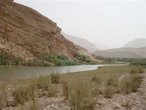
This river originated from south of Kabirkuh, which is located 42 kilometers far from north of Dehloran in the west of Tang Sheikhan. First, it joins Ab Anjireh River then passes a valley in Sahand Mount in west and Dal and Dinarud in the east, then join some tributary and Ab Sivan River and pour to Meymod 25 kilometer far from northwest of Dehloran. This river is 25 kilometers long and the height of its source is 1600 meter.

  • Please feel free to call us on 00989020038045 (Phone, Whatsapp, Telegram) or contact by info@mustseeiran.com, if you require any further information.
    Follow us on Instagram @mustseeiran.com_insta

Changuleh River of Mehran

Changuleh River of Mehran

Changuleh River is made by Tank Khoshuk and Tang Kortu Rivers confluence 53 kilometers far from east of Mehran. First, it joins Tima River and after passing, Tima Village reaches Mehran-Dehloran Road. 80 kilometers far from northwest of Dehloran, exit Iran Iraq border and enter Iraq and in Sheikh Sad Village pours in Dejleh River. This river is 84 kilometers long from its furthest source to Iran Iraq border and from its formation to Iran Iraq border is 45 kilometer and the height of its source is 150 meter.

  • Please feel free to call us on 00989020038045 (Phone, Whatsapp, Telegram) or contact by info@mustseeiran.com, if you require any further information.
    Follow us on Instagram @mustseeiran.com_insta

Ilam Parks

Ilam Parks

Ilam is covered by natural forests because of its geographic position, its weather, high amounts of rainfall. Although as time passes its area and forest density decreased, it is still one of the eye-catching and beautiful districts among other provinces.
This district has great jungles, trees, and forests which are located in tropical areas once, and still, some of these green areas are visible from north of the Province which are mostly Oak species.
Besides what has been mentioned, this district has two products; Turpentine and Tragacanth, which is the business of most inhabitants.
The jungle area has been estimated 500 thousand Hectare. Here are some of its trees species; Pistacia terebinthus, Acer monspessulanum, Howthorn, Almond, Fraxinus excelsior, Common fig, Cercis siliquastrum, Sweet Cherry, Myrtle, Jujube, Prunus scoparia.

  • Please feel free to call us on 00989020038045 (Phone, Whatsapp, Telegram) or contact by info@mustseeiran.com, if you require any further information.
    Follow us on Instagram @mustseeiran.com_insta

Promenades of Ilam

Forest promenade like Male Panjav, Haji Bakhtiar and Abza, Manjal, Tang Arqavan around Ilam.
Forest promenade is near Mehram dome, and Kanjan Cham River is located 6 km far from Slehabad of Mehran County.
Beautiful nature of Tang Qir in Chardavol.
Plains and pasture’s view of Shirvan and Chardavol.
Nature of Sohrab Promenade in Abdanan.
Natural views of Kabirkuh and Seymareh River in Darreh Shahr County.
Natural views of Anaran Mounts in Abdanan County.

  • Please feel free to call us on 00989020038045 (Phone, Whatsapp, Telegram) or contact by info@mustseeiran.com, if you require any further information.
    Follow us on Instagram @mustseeiran.com_insta

Holeylan Rural District of Shirvan and Chardavol

Holeylan Rural District

Holeylan Rural District of Shirvan and Chardavol County has eight historical hills belonged to different periods through history. Some of them had been registered and researched.

  • Please feel free to call us on 00989020038045 (Phone, Whatsapp, Telegram) or contact by info@mustseeiran.com, if you require any further information.
    Follow us on Instagram @mustseeiran.com_insta

Shiakh Castle of Dehloran

Shiakh Castle of Dehloran

Shiakh castle is located between two rivers in Wileh Strait. Takht Piran is located northwest of Zarin Abad and Takhte Nile in the northeast of Zarinabad of Dehloran County near Bardi Village.
This castle belonged to the Sasanian Dynasty and made from stone and mortar. It was near Beinolnahrein River and was used as a warehouse at that time. Remains of the castle are one thousand meters long, seven to ten meter high and its thickness is about two meters.
Remains of the castle rooms, which was once living place of commanders, are still visible.
People, who lived there, built a water channel, made of stone and mortar, and supply their drinking water from Vile Strait. A natural slope of the ground pours the water to the castle. In the north of the castle and its hills were two old towers which were scout towers.

  • Please feel free to call us on 00989020038045 (Phone, Whatsapp, Telegram) or contact by info@mustseeiran.com, if you require any further information.
    Follow us on Instagram @mustseeiran.com_insta

Jam Namasht Bridge of Dare Shahr

This bridge is located in Seimare River, 4 km far from north of Darreh Shahr, in front of Cham Kalan Village. Its structure materials are rubbles and mortar. Presently, its external bases breakwaters remain. Some of IIam castles
– Hezarani Historica Castle belonged to Sasanian Empire and is located in Hezarani Village of Abdanan County. Renovating the castle could be one of the important tourist attraction sites.
– Paqofleh Historical Castle
– Sasani Anjir Castle in Zarinabad
– Remains of the historical castle of Sasanid Dynasty in Kambakhsh Badreh of Darreh Shahr County.
– Remains of Posht Qale Castle in Abdanan County.
– The wall of Gamul Castle in Barikeh Village
– A castle made of stone and mortar and belonged to the Sasanid Dynasty is located in Mimeh of Zarinabad.
– Ismail Khan Castle in Sivan Mounts near Ilam City and Plain.
– Remains of prehistory buildings in Katan Gonbad of Saleh Abad.
– A carved wall which belonged to Parthian and Sasanian in Mimeh of Zarinabad.

  • Please feel free to call us on 00989020038045 (Phone, Whatsapp, Telegram) or contact by info@mustseeiran.com, if you require any further information.
    Follow us on Instagram @mustseeiran.com_insta

Krudit Bridge (Pesar va Dokhtar) Bridge of Chardavol

This historical bridge which belonged to Sasanid Dynasty is located in Chambur Village of Chardavol. It was identified by Iran National Heritage Organization.

  • Please feel free to call us on 00989020038045 (Phone, Whatsapp, Telegram) or contact by info@mustseeiran.com, if you require any further information.
    Follow us on Instagram @mustseeiran.com_insta

Gavmishan Bridge

Gavmishan Bridge

Govmishan Bridge is built in Samera Riverway and Kashkan River confluence. Its structure belonged to the Sasanian Empire but its brick arches and stones indicate that they are renovated recently.
This bridge was renovated by Hassanqoli Khan Abuqadare, commander of Poshtkuh. Nowadays, the bridge is half destroyed.

  • Please feel free to call us on 00989020038045 (Phone, Whatsapp, Telegram) or contact by info@mustseeiran.com, if you require any further information.
    Follow us on Instagram @mustseeiran.com_insta

Tikhan (Tiqan) Hill of Dare Shahr

This hill is located in the northeast of DareShahr, 2 km far from the right side of Simereh River and in the Jamshidabad Village’s farms.
It is estimated that this hill was a four-floor structure once. In its first floor, some brick potteries, flint and triangle green stones had been found.

  • Please feel free to call us on 00989020038045 (Phone, Whatsapp, Telegram) or contact by info@mustseeiran.com, if you require any further information.
    Follow us on Instagram @mustseeiran.com_insta