Chardavol River of Ilam

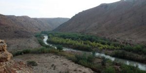
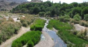
This river is shaped by Chenarch and Ab Aseman River confluence in Cheshmeh Kabud Village, 22 kilometers far from northeast of Ilam. It joins Seimareh River after passing Chardavol Village in the south of Veleh Baz, seven kilometers far from northeast of Lumar. The river is 22 kilometers long and its source height is 900 meters.

  • Please feel free to call us on 00989020038045 (Phone, Whatsapp, Telegram) or contact by info@mustseeiran.com, if you require any further information.
    Follow us on Instagram @mustseeiran.com_insta

Chenarch River of Ilam Province

This river is made by Ab Chika and Do Ab confluence 1 kilometer far from southeast of Kalk Jafar Village. After passing valleys between Banhazar Mount in East and Khormeh and Sepahpir Mounts in the west and joining two tributaries in Cheshmeh Kabud Village, pours in Ab Aseman River and shape Chardavol River. Its length and source height are 20000 and 1150 meters orderly.

  • Please feel free to call us on 00989020038045 (Phone, Whatsapp, Telegram) or contact by info@mustseeiran.com, if you require any further information.
    Follow us on Instagram @mustseeiran.com_insta

Chovar River of Ilam

This river originated from west of Gavehrah, 7 kilometers far from northwest of Ilam. It joins Murt River after passing Bahmanabad and Chovar River then enters the north valley of Tavashir Khani Mount and continues to Bandozeh Village and after two kilometers reaches Khosh River. This river is 25 kilometers long and its source height is 1400 meter.

  • Please feel free to call us on 00989020038045 (Phone, Whatsapp, Telegram) or contact by info@mustseeiran.com, if you require any further information.
    Follow us on Instagram @mustseeiran.com_insta

Khosh River of Ilam

Khosh River of Ilam

This river is made by Kalal and Gilan Kurgeh River confluence 25 kilometer far from west of Ilam. joining Chovar River in the east of Kach Mount, it supplies Cheshmehsar drinking water, round Sekurand Mount and joins some tributaries and exit Iran borders 54 kilometers far from southwest of Ilam. This river is 50 kilometers long and its source is 650 meters high.

  • Please feel free to call us on 00989020038045 (Phone, Whatsapp, Telegram) or contact by info@mustseeiran.com, if you require any further information.
    Follow us on Instagram @mustseeiran.com_insta

Sadeh River of Ilam

Sadeh River is located in Chovar County of Ilam. Drainage basin of this river is the Persian Gulf and the Gulf of Oman. The river is 25 kilometers long in Iran and its source height is 900 meter. Its source is 51 kilometers far from northwest of Ilam from Gachhaye Boli Mount.

  • Please feel free to call us on 00989020038045 (Phone, Whatsapp, Telegram) or contact by info@mustseeiran.com, if you require any further information.
    Follow us on Instagram @mustseeiran.com_insta

Kenjan Cham River of Ilam

Kenjan Cham River of Ilam

This river originated from Shalam, Sarkab and Maladshah River which are located 7 kilometers far from south of Ilam. It joins Ab Aftab River in Golgol Gachan District and after passing a narrow valley enters Mehran County.
It first passes Amirabad Village and then runs to Kenjan Village Cham. It joins Siah Ab and Cheshmeh Malek, Goldar Khosh River orderly, then runs to Kenjan Cham Village. After passing east part of Zalu Mount runs to Iran Iraq Border, enters Iraq 9 kilometers far from east of Mehran and would be considered border river 4 kilometers far from Mehran. Its name in Iraq is Sirav. It is 90 kilometers long before its entrance to Iraq and its source high is 1800 meter.

  • Please feel free to call us on 00989020038045 (Phone, Whatsapp, Telegram) or contact by info@mustseeiran.com, if you require any further information.
    Follow us on Instagram @mustseeiran.com_insta

Ab Asiab River of Darreh Shahr

Ab Asiab River is located in Darreh Shahr District. The river length is 30 kilometers and the height of its source is 1500 meter.
This river has passed Tong Valley which is located in Dageh Mount in its eastern part and Govar Mount in its western part.

  • Please feel free to call us on 00989020038045 (Phone, Whatsapp, Telegram) or contact by info@mustseeiran.com, if you require any further information.
    Follow us on Instagram @mustseeiran.com_insta

Garab River of Ilam Province

This river originated from Chamangir Mount. After passing Valandtar and Asiahvoleh Villages and Jaber Imamzadeh in Banaparvar District join Rubehrud and then pour Seimareh. It is 40 kilometers long and its source is 2400 meter high.

  • Please feel free to call us on 00989020038045 (Phone, Whatsapp, Telegram) or contact by info@mustseeiran.com, if you require any further information.
    Follow us on Instagram @mustseeiran.com_insta

Ab Murmuri River of Dehloran

This river is located 4 kilometers far from northwest of Murmuri Village, and originated 38 kilometers far from northeast of Dehloran. After passing Murmuri Village, enters a valley in Dalpari Mount and pours in Chikhab River 38 kilometer far from southeast of Dehloran. The river is 25 kilometers long and the height of its source is 550 meter.

  • Please feel free to call us on 00989020038045 (Phone, Whatsapp, Telegram) or contact by info@mustseeiran.com, if you require any further information.
    Follow us on Instagram @mustseeiran.com_insta

Chay Qareh Tappeh River of Dehloran


Chay Qareh Tappeh River of Dehloran

This river is made by Gardeh Bishe River and Se Galan confluence 30 kilometers far from northwest of Dehloran. it joins three tributaries 37 kilometers far from west of Dehloran to Iran border. The river is 15 kilometers long.